
Puerto Rico Silhouette: What Does Puerto Rico’s Outline Look Like on a Map?
Guessing the Worldle answer in a single try (what many players call a 1/6 win) usually requires familiarity with the shapes of countries and territories around the world. Players who regularly study map outlines tend to recognize these silhouettes quickly, while others gradually improve through practice and repeated gameplay.
In this post, we’ll take a closer look at the silhouette of Puerto Rico. Puerto Rico was the Worldle answer for March 9, 2026, so if you played the game on that day—or if you’re solving past puzzles through a Worldle Archive—this guide can help you understand the outline that appeared in the game.
Below, you’ll find an overview of the Puerto Rico silhouette along with helpful facts about its location, capital city, neighboring islands, and other details that explain the territory behind the shape.
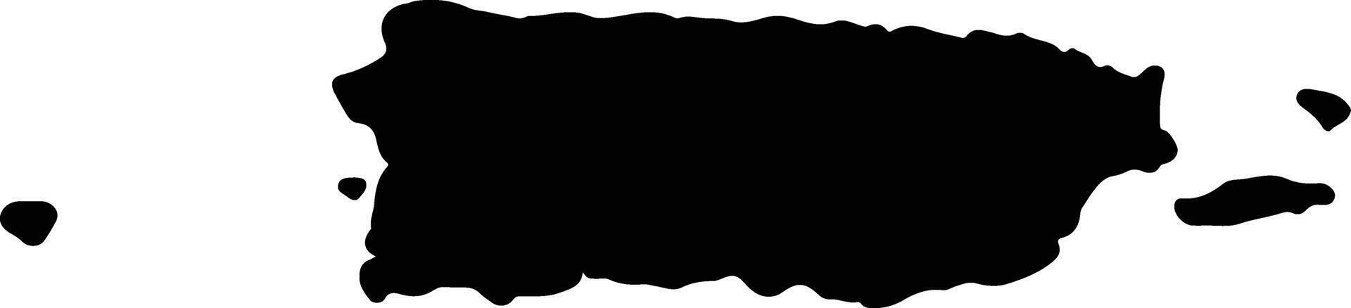
Puerto Rico Silhouette
Puerto Rico’s silhouette is fairly recognizable once you’ve seen it a few times. The island has a mostly rectangular shape that stretches from west to east, with slightly curved northern and southern coastlines.
Because it is an island, its borders are entirely coastline rather than land boundaries with other countries.
Puerto Rico Location
Puerto Rico is located in the Caribbean Sea, part of the greater Caribbean region of North America. The island lies east of the island of Hispaniola and west of the Virgin Islands. It sits between the Atlantic Ocean to the north and the Caribbean Sea to the south.
Because of its position in the Caribbean, Puerto Rico has long been an important hub for trade, shipping, and cultural exchange between the Americas and Europe.
Continent or Region That Puerto Rico Belongs To
Puerto Rico belongs to the Caribbean region, which is considered part of North America geographically.
Politically, Puerto Rico is an unincorporated territory of the United States, meaning it is under U.S. sovereignty but is not a U.S. state.
Puerto Rico Capital City
The capital city of Puerto Rico is San Juan.
Located along the island’s northern coast, San Juan is the largest city in Puerto Rico and serves as its political, economic, and cultural center. The city is famous for its historic district, Old San Juan, colorful colonial buildings, and large harbor that has served ships for centuries.
Major Cities in Puerto Rico
Besides San Juan, several other cities play important roles across the island:
- Bayamón – a major city located just west of San Juan and part of the island’s metropolitan area.
- Ponce – the second-largest city, located on the southern coast and known for its historic architecture and cultural heritage.
- Mayagüez – an important port and university city on the western side of the island.
- Carolina – home to the island’s main international airport and located just east of San Juan.
Each of these cities contributes to Puerto Rico’s economy, culture, and tourism.
Puerto Rico Borders
Since Puerto Rico is an island, it does not share land borders with other countries. However, it sits near several neighboring islands in the Caribbean.
Nearby territories and countries include:
- Dominican Republic to the west
- British Virgin Islands to the east
- U.S. Virgin Islands just east of Puerto Rico
These islands together form part of the Greater Antilles and surrounding Caribbean island chains.
How Big Is Puerto Rico?
Puerto Rico covers an area of about 9,100 square kilometers (3,515 square miles).
Although relatively small, the island has a diverse landscape that includes:
- Mountain ranges in the interior
- Tropical rainforests such as El Yunque National Forest
- Coastal plains and beaches
- Rivers and lush valleys
The island’s population is roughly 3.2 million people, making it one of the most populated islands in the Caribbean.
Why Does Puerto Rico’s Silhouette or Outline Look the Way It Does?
Puerto Rico’s outline is largely shaped by natural coastal geography rather than political borders with neighboring countries.
Over time, erosion, ocean currents, and geological activity helped form the island’s coastlines. The result is a long, slightly curved island that stretches east to west with small peninsulas and bays along its edges.
Because the island is relatively compact and rectangular, its silhouette is often easier to recognize in geography puzzle games compared with more irregular island shapes.
Are There Similar-Looking Country Shapes?
Puerto Rico’s silhouette can sometimes resemble other small Caribbean islands when viewed in a simplified map icon.
For example:
- Jamaica can appear somewhat similar in certain small silhouettes.
- Cyprus may occasionally confuse players when viewed quickly in outline form.
However, Puerto Rico’s east–west rectangular shape usually helps distinguish it from other islands once players become familiar with it.
Five Interesting Facts About Puerto Rico
Here are five quick facts about Puerto Rico:
- U.S. territory: Puerto Rico has been a territory of the United States since 1898.
- Two official languages: Both Spanish and English are official languages on the island.
- Home to a tropical rainforest: El Yunque National Forest is the only tropical rainforest in the U.S. National Forest system.
- Bioluminescent bays: Puerto Rico is famous for several glowing bays where microscopic organisms light up the water at night.
- Rich cultural heritage: Puerto Rican culture blends Spanish, African, and Indigenous Taíno influences, creating a unique mix of music, cuisine, and traditions.